WEATHER — PUBLIC SAFETY — FLORIDA
Hurricane Isaias Nears Florida as Category 3 Storm
Isaias was 90 miles south of Pensacola at 4 p.m. Central time, with 115 mph sustained winds. The National Hurricane Center expected landfall on the western Florida Panhandle Friday evening and warned residents in surge and hurricane zones to be in safe shelter.
By Health Politics Daily News Desk · Published Friday, October 9, 2026 at 8:00 p.m. America/New_York · Approximately 8 minutes

Watch in this article
Pumpjack operating at the Kern River Oil Field
A short CC0 field video provides visual context for reporting on oil production and fuel supply.
Thomas Farley / Wikimedia Commons · CC0 1.0 · License and source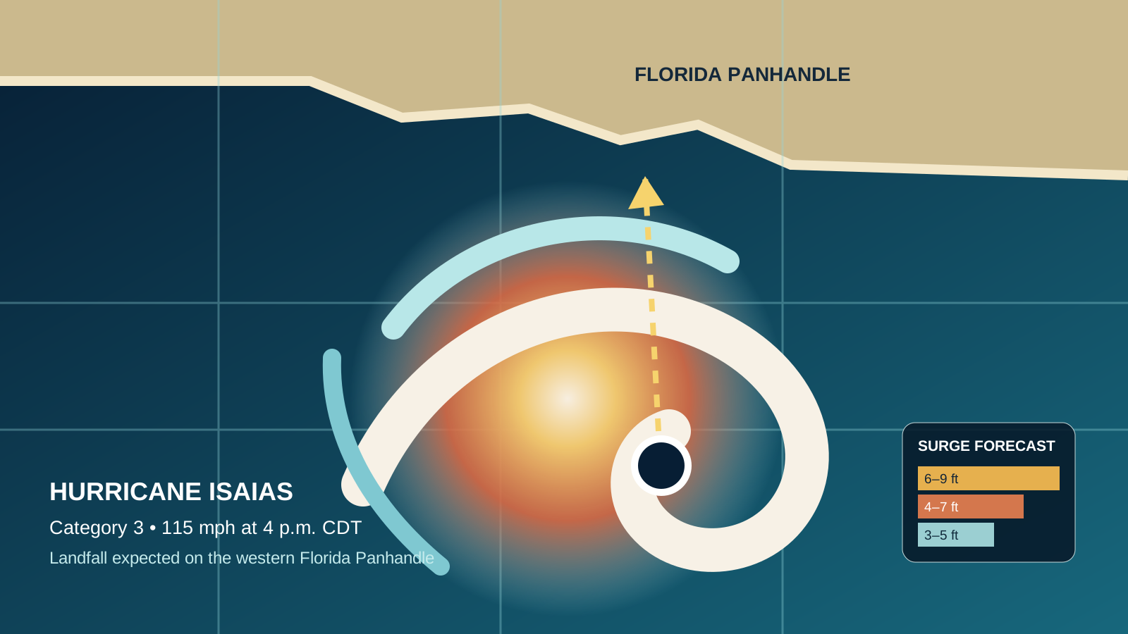
Verified Baseline
A major hurricane was approaching the western Florida Panhandle
At 4 p.m. CDT Friday, the National Hurricane Center’s Advisory 13 placed Isaias at 29.2°N, 87.0°W—about 90 miles south of Pensacola and 125 miles south-southeast of Mobile. Maximum sustained winds were 115 mph, the minimum pressure was 959 millibars and the storm was moving north at 17 mph.
The center forecast landfall along the western Florida Panhandle Friday evening, followed by a track across Alabama and into the Tennessee Valley. Little change in strength was expected before landfall; weakening was forecast afterward. Hurricane-force winds extended up to 35 miles from the center and tropical-storm-force winds up to 205 miles.
Verified fact: Isaias was a Category 3 hurricane when the 4 p.m. advisory was issued. Forecast: the location and exact intensity at landfall could still change. Public-safety baseline: local evacuation orders and National Weather Service alerts take precedence over generalized regional reporting.
The Main Hazards
Surge, wind, rainfall and tornadoes threaten different places
The highest surge forecast—6 to 9 feet above normally dry ground—covered the Alabama–Florida border to Grayton Beach, Florida. The NHC forecast 4 to 7 feet from Grayton Beach to Indian Pass, 4 to 6 feet from Indian Pass to the Steinhatchee River and from Dauphin Island to the Alabama–Florida border, and 3 to 5 feet across several adjoining stretches. Actual inundation depends on track, wind direction, tide, waves and local terrain.
Across southern Alabama, the Florida Panhandle and Big Bend, the forecast called for 4 to 8 inches of rain, with localized totals up to 15 inches. Flash, urban and river flooding were possible, and considerable impacts were likely in parts of southern Alabama, the Panhandle and southwestern Georgia. Tornado risk extended Friday night across the Panhandle, southeast Alabama and southern Georgia, shifting farther inland Saturday.
Storm category describes sustained wind near the center; it does not measure rainfall, tornado or surge risk. People outside the narrow hurricane-force wind core can still face dangerous flooding, falling trees, power loss and impassable roads.
Why It Matters
The storm is already affecting power, travel and energy supply
Associated Press reported mandatory evacuations in parts of Florida, Alabama and Mississippi, airport and beach closures, curfews and National Guard mobilization. Those measures vary by county and can change as conditions worsen. Residents should use county emergency management, local law enforcement and the National Weather Service for the latest instructions.
The economic effects extend offshore. Reuters reported that operators had shut in about 1.5 million barrels per day of Gulf oil production and 1.3 billion cubic feet per day of natural gas—roughly 72% and 59% of Gulf output. Personnel had been evacuated from 129 staffed platforms and eight additional rigs. Those figures show a large temporary precautionary shutdown; they do not by themselves predict a lasting national fuel shortage or a specific retail-price change.
After landfall, the hazard shifts rather than ends. Isaias is expected to weaken, but heavy rain, flash flooding, gusty winds and tornadoes may spread through Alabama, Georgia, the Carolinas and parts of the Tennessee Valley.
Practical Implications
What residents, travelers and families should check now
- If officials ordered an evacuation: follow that instruction; do not use the forecast track line as a reason to stay.
- If sheltering: remain in an interior room away from windows and keep emergency alerts enabled. Do not leave during a temporary lull that may be the eye.
- Near the coast or rivers: never drive or walk through floodwater. Surge can rise quickly and roads may be hidden or washed out.
- Using a generator: operate it outdoors, far from doors, windows and vents; carbon monoxide cannot be seen or smelled.
- For travel: confirm flights and road conditions directly with carriers and state transportation agencies. Airport reopening times may move.
- For medical needs: keep medications, charging equipment and emergency contacts accessible, and call local emergency services for immediate danger.
What Remains Uncertain
Small track changes could move the worst surge and wind
The strongest winds and highest surge occupy only part of a hurricane’s circulation. A shift of several dozen miles can materially change which communities receive the most destructive onshore flow, while damaging rain bands and tornadoes can occur well away from the center.
Analysis: the official advisory supports treating Isaias as a multistate emergency, not only a Pensacola wind event. The combination of a compact hurricane-force core and a broad tropical-storm wind field widens the area of potential power and travel disruption.
Forecast: weakening after landfall is likely, but inland impacts may persist through the weekend. The timing and placement of the heaviest rain bands are less certain than the broad regional threat.
Opinion: Health Politics Daily does not issue evacuation advice. When an official warning conflicts with a social-media post or a single model image, the official local instruction is the safer source to follow.
Bias Lens: how coverage frames Hurricane Isaias
The NHC reported 115 mph sustained winds at 4 p.m. CDT, expected western-Panhandle landfall Friday evening, a 6–9-foot maximum surge forecast and localized rainfall totals up to 15 inches.
Left-leaning coverage: The Guardian foregrounds rapidly deteriorating conditions, outages and public warnings. Center coverage: Associated Press emphasizes evacuations, closures and household preparations, while Reuters also quantifies offshore energy shutdowns. Right-leaning coverage: Fox Weather leads with meteorological timing, wind shear and the broad inland rain and tornado threat.
The differences are mostly emphasis, not disagreement over the core facts. All rely substantially on the National Hurricane Center; the official advisory is the baseline for intensity, forecast track and hazard zones.
Principal Sources
Official forecast and corroborating reporting
- National Hurricane Center — Hurricane Isaias Advisory 13
- National Weather Service — local warnings and forecasts
- Associated Press — evacuations, closures and preparations
- Reuters — Gulf oil and gas shutdowns
Fox Weather’s authorized interview with NHC Director Michael Brennan is linked in the Bias Lens rather than embedded because site-level embedding permission was not independently confirmed.