Global events · India · Extreme weather
Cyclone Arnab Intensifies as Eastern India Expands Evacuations Ahead of Landfall
India's weather agency says the very severe cyclone is likely to cross the Andhra Pradesh coast near Yanam on Wednesday morning. Authorities are moving residents from exposed communities as the forecast includes destructive winds, dangerous seas, flooding rain and storm surge.
By Health Politics Daily News Desk · October 26, 2026 at 9:56 p.m. ET

Watch in this article
Pumpjack operating at the Kern River Oil Field
A short CC0 field video provides visual context for reporting on oil production and fuel supply.
Thomas Farley / Wikimedia Commons · CC0 1.0 · License and source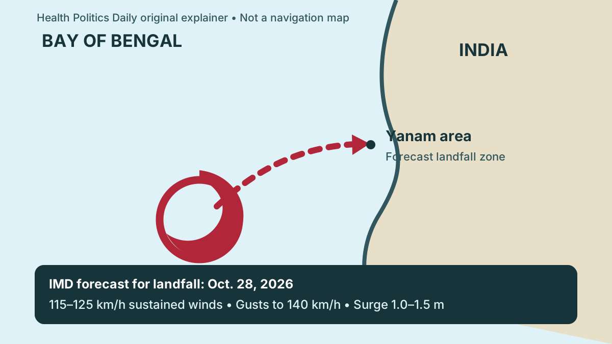
Verified baseline
In its coastal bulletin valid late Monday, the India Meteorological Department classified Cyclone Arnab as a very severe cyclonic storm over the west-central Bay of Bengal. At 6 p.m. UTC on October 26, its center was about 350 kilometers southeast of Visakhapatnam and 420 kilometers east-southeast of Kakinada.
The agency forecast that Arnab would cross the Andhra Pradesh coast between Bapatla and Visakhapatnam, close to Yanam, during the morning of October 28. That location, timing and strength are forecasts and can change as the storm moves closer.
What the latest forecast means
IMD forecast sustained winds of 115–125 kilometers per hour at landfall, with gusts to 140 kilometers per hour. Its sea-area bulletin warned of very high to phenomenal seas near the storm center. The coastal forecast also projected a storm surge of about 1.0–1.5 meters above the astronomical tide in low-lying parts of Andhra Pradesh, with the greatest rise around Kakinada and Yanam.
Those conditions can damage weak structures, uproot trees, interrupt electricity and communications, and push seawater into exposed coastal areas. Heavy rain can also cause dangerous inland flooding even outside the immediate landfall point.
Evacuations and health preparations
Reuters reported that Andhra Pradesh authorities had identified roughly 570,000 vulnerable people as evacuations expanded. The Indian Express reported that officials had moved 4,711 pregnant women into hospitals and health centers and closed schools in exposed areas.
India's National Crisis Management Committee reviewed preparations with state and national agencies, including rescue teams, medical support and continuity of essential services. The number of people moved may rise as local orders change.
Practical implications
People in the forecast area should use current IMD bulletins and instructions from state and district authorities, leave promptly if ordered, and avoid beaches, ports, flooded roads and downed power lines. Essential medicines, identity documents, drinking water and charged communications devices should travel with anyone relocating. Fishers should follow official restrictions rather than use this article as a marine forecast.
Travelers and families outside the region should check directly with rail, airline, school and local emergency services because cancellations and shelter plans can change quickly. This is general public-safety information, not individualized medical advice.
Fact, analysis, forecast and opinion
Verified fact: IMD classified Arnab as a very severe cyclonic storm and authorities began evacuations and health preparations. Forecast: landfall location, timing, wind speed, surge and rainfall are official projections, not completed events. Analysis: early movement of pregnant people and other vulnerable residents reduces the chance that emergency transport will be needed during the most dangerous conditions. Opinion: Health Politics Daily supports clear, accessible evacuation communication and does not endorse any political party or government.
Bias Lens: disaster logistics, meteorology or a wider climate story?
Verified baseline: IMD places Arnab over the Bay of Bengal and forecasts landfall near Yanam on October 28 with destructive winds and storm surge. Evacuations are underway; the final track and impacts are not yet known.
Left-leaning international coverage: The Guardian places Arnab within a broader report on simultaneous severe-weather events, emphasizing the global pattern and human effects. Center wire coverage: Reuters foregrounds the evacuation count, government preparations and economic disruption. Weather-specialist coverage: The Washington Post emphasizes intensification, track and hazards.
No comparably detailed mainstream right-leaning report was available at publication. Rather than force false symmetry, the comparison shows the meaningful difference in the available reporting: broad extreme-weather context, operational response and storm mechanics.
What remains uncertain
A small track shift could change which communities receive the strongest winds or highest surge. Arnab's intensity at landfall, the exact rainfall distribution, infrastructure failures and the duration of transport interruptions remain uncertain. Official bulletins should supersede the figures in this article as new observations arrive.
Principal sources
- India Meteorological Department — coastal forecast and warnings
- Government of India — national preparedness review
- Reuters — evacuations and operational response
- Indian Express — health transfers and local measures
No suitable official or publisher-authorized video with clear downstream embedding permission was available, so no video was embedded.